When I was a kid, my Dad used to take me fishing in Rhode Island a lot, usually in Westerly,RI next to an old lighthouse that was manned by the Coast Guard. But in recent years, the Coast Guard made the lighthouse unmanned, and sold the property to a private owner - who then cut off access to the point (a locally known hot spot for striped bass and bluefish). I heard rumors that the owner didn't want anybody out there carving up their catch, and leaving the remains everywhere for seagulls to eat & crap everywhere.
When I tried to find out more information about "Camp Cronin" itself, to give you, the reader some type of background on this hot spot, I came to many "dead ends". There is literally no information containing the words "Camp Cronin", whether it was a former military encampment, installation, base, etc.. So, I did some research on past military forts of World War II, and I came across this web page on NorthAmericanForts.com , about "Fort Nathaniel Greene (2) aka Battery 211".
This is what I found out:
Fort Nathaniel Greene (2)*
(The Point Judith Fishermen's Memorial)
(1934 - 1948/present), Point Judith
Originally named Point Judith Reservation until 1941. Fort Greene is divided into three separate sections. The East Reservation has Battery Hamilton / 108 (1943 - 1948). The RI National Guard still uses this parcel as a training area.
The West Reservation has Battery 109 (1944). The present is named "The Fishermen's Memorial State Park" which uses this parcel as a campground, as well as most of the former southern parcel. The park office incorporates a former battery command - fire-control tower/silo (Photo 1). The South Reservation* has Battery 211* (1945 - 1948) at the water's edge, and an unnamed four-gun 155mm battery on Panama mounts - two are mostly buried under the beach, the other two were washed away from Hurricane Sandy. "The Point Judith Fishermen's Memorial" is located at Battery 211* (which is buried under the Fishermen's Memorial itself). Three fire-control stations were once located near here at the present Camp Cronin Recreation Area, disguised to resemble typical New England style beach houses. One still remains.
(Not to be confused with Fort Greene (1) in Newport)


(Not to be confused with Fort Greene (1) in Newport)

Fort Greene Fire Watch Tower

Fort Greene Fire Watch Tower is now part of the Main Office for the "Fisherman's Memorial State Park"

Fort Greene Fire Control Building - the building is in an advanced state of decay, and the property is currently owned by the city of Providence,RI.
To learn more about Fort Greene [2], click the link.
Photo #'s 1, 2, & 3 Credits: John Stanton & Bill Thayer

Photo #4 Credit: Chris Zeeman

Photo #5 Credit: Chris Zeeman
For more info, Click here: Battery 109
*Author's Note: I made some changes to this article here to clear up some confusion. "The Point Judith Fishermen's Memorial" is located here, and is NOT to be confused with the "The Fishermen's Memorial State Park", which is now a campground for RVs & Motorhomes located a few miles away. Click the link for a dark secret about RI's participation in World War II!
Anyway, I've always enjoyed searching for new places to launch my kayak, and get out on the open water. And, this place doesn't disappoint! I will extend some caution though, I would classify this particular spot as an "advanced/experienced-only" launch spot. Most people wouldn't venture out past the break on the East wall. I would leave that up to the more advanced kayak anglers in our group. Trust me, you REALLY have to keep your eye on the tidal currents by the Red Buoy Marker on your left coming out of the East wall! Between the currents coming at you from the East, South, and North (out of the Harbor of Refuge) and the big sport fishing boats leaving Point Judith Harbor, you will have your hands full as you try to navigate your kayak to your favorite hunting grounds East of Point Judith Lighthouse.


Camp Cronin in it's earlier years. In this photo, the Pt. Judith Fisherman's Memorial didn't exist.
Photo #6 Credit: KayakAccess.info

Photo #7 Credit: YankeeMagazine.com

Visitors walk along the top of the East wall at sunset.
Photo #8 Credit: HiveMiner.com

The sun sets behind the info board at the Camp Cronin Fishing Area.
Photo #9 Credit: NewEngland.com

Photo #10 Credit: NewEngland.com

Beachgoers take in the midday sunshine behind the East wall at the Point Judith Back Beach at Camp Cronin. This stretch of deep sand will require your kayak's cart be equipped with beach tires (aka balloon tires). It will make your trek across the sand a lot easier.
Photo #11 Credit: HiveMiner.com

A commercial fishing vessel makes its way back to Point Judith Harbor, via cutting through the Harbor of Refuge at high tide, to unload its daily catch. Those of us that choose to fish the East break wall, may have to dress appropriately, for the incoming high tide could cause you to go home soggy.
Photo #12 Credit: HiveMiner.com

RISAA Kayak Committee members Anthony & Stephanie Caruolo prepping their gear for an afternoon launch. Both Anthony & Stephanie caught several fluke by staying inside the channel next to the green tower at the other break's end.
Photo #13 Credit: Mona Rodriguez

RISAA Kayak Committee members Jeff Hall (left) and Gino DeFeudis (right) discuss their options on where to fish.
Photo #14 Credit: Mona Rodriguez

Jeff & Gino launching (in the slack tide) during the high tide.
Photo #15 Credit: Mona Rodriguez

Jeff sets up his Hook 5 fishfinder, while Gino checks all the hatches making sure everything is secure.
Photo #16 Credit: Mona Rodriguez
While these photos above were taken in August, on a relatively calm and perfect day, it's hard to believe that anything could wrong. But in 2012, one of the state's most destructive hurricane's, "Hurricane Sandy" (aka Superstorm Sandy) slammed into the Rhode Island coast with such force that it literally decimated the parking area, the fisherman's memorial, and the barrier wall protecting the Harbor of Refuge. The RIDEM (Rhode Island Dept. of Environmental Management) applied for federal grants to aid in rebuilding the parking area, the memorial, and the East wall/coastline.

The waves from the hurricane were so destructive that it picked up large boulders, some as big as a small compact car, and strewn them all over the parking area. Here, local residents survey the damage caused by Hurricane Sandy.
Photo #17 Credit: RIstripedbass.blogspot.com

During the rebuilding process, a drone cam captures the construction crews carefully arranging the large stones into a better built wall, making sure the coastline is better protected from future disasters.
Photo #18 Credit: DredgingToday.com

The Point Judith Fisherman's Memorial now sits next the Overlook, where this photo was taken, and to the left of the parking area. The "overlook" is actually the remains of the Radio Room that was built in 1944. Rather than demolishing it, the state of RI chose to "bury it" under a mound of dirt. The entrances in the front & back of the structure were blocked off with huge stones to prohibit entry into the structure, but a few brave souls managed to wriggle their way in and spray graffiti on the walls.
Photo #19 Credit: FlickrHiveMind.net

Photo #20 Credit: John Stanton

This is the rear entrance of the radio room, which faces the shore, but is blocked off with large boulders to prevent entry into the structure.
Photo #21 Credit: Jeff Hall

Before Hurricane Sandy came, this structure was one of two battery gun emplacements that protected Point Judith from enemy attacks.
Photo #22 Credit: John Stanton

Both this photo, and the one above, were taken before Hurricane Sandy. A combination of rising sea levels and stronger storms, have worked together to erode the large concrete plates around the turret tower base, and wash them out to sea. Slowly erasing Rhode Island's participation in World War II's history.
Photo #23 Credit: Chris Zeeman

This photo was taken recently in January 2017.
Photo #24 Credit: Jeff Hall

This is the second turret base that sits to the right of the radio room. It sits a little further back than the other base.
Photo #25 Credit: Chris Zeeman

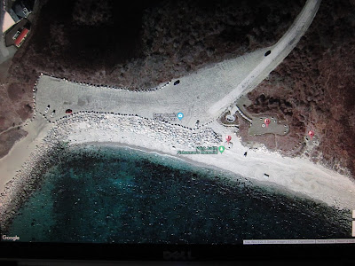
Today, this is the new and improved Camp Cronin Fishing Area parking lot. The two white cars on the far left, is where you would put in the kayaks - provided you have a kayak cart that handle deep sand. The large rocks at this entry point are wide enough to get your kayak through and down to the shoreline on the inside of the East barrier wall.
Photo #26 Credit: Jeff Hall via Google Maps

The stretch of sand that leads down to the protected area to launch is roughly 200 feet long (longer if it's low tide). If you don't have flotation tires, you are going to regret it, as dragging a fully loaded kayak will feel like you're dragging it without tires. There is no way to drive down to launch. It's not a well used launch point, because of the distance & the deep sand involved. When night falls, the action heats up for both surfcasters and kayak fishermen when the fish change direction. This will be a hot spot for years to come as it leads out to the open waters with views of Block Island a short distance away.
Photo #27 Credit: Jeff Hall via Google Maps
As usual, keep those lines wet & tight! - J
*Author's Note: I would like to thank all those involved with the making of this article. Without your photos, this article would've been a lot shorter. Don't forget to click the links and visit the photographer's pages as well.

Photo #28 Credit: Yelp.com

Photo #29 Credit: Elevation.Maplogs.com

Photo #30 Credit: MichaelBlanchette.com
No comments:
Post a Comment