Monday, May 26, 2014

Oops! That's not supposed to happen!


Saturday, May 24, 2014, 6 pm

     I posted on our kayak fishing club's private email board the other night about possibly launching at Ninigret Pond's "East Beach Parking Area". There are 4 spaces each on the left and right at the first parking entrance before the fenced area. After a certain time (11 pm), that main area gets chained off.

     Anyways, shortly after I got geared up, I was joined by fellow RISAA - Kayak members Mo Rodriguez & Don Goodroe, which after a short walk across the parking lot, we headed down to the water's edge with our kayaks in tow and launched at what appeared to be almost high tide. We then paddled out to Hall Point, which was about 2.25 miles away. Once we got there, there was another boat with 2 men using fly fishing gear on a small skiff anchored in a shallow cove with a depth of about 2.5 ft. The cinder worms were barely present but the fish were making their presence known by splashing around at the very top of the water. They were everywhere!

     We stayed until about 8:30 pm and started to head back. The wind was picking up while the clouds thickened. Our paddle back seemed longer because the wind was in our faces. Mo asked for an assist in turning on her mast light so we could be seen on the way back to the launch area. Don turned on his own custom made light. Then, I went to turn on my light, and all I got was nothing. WTF!  That's not supposed to happen! Fresh batteries were installed last week, so I didn't know what the problem was. We decided to hug the East Beach shoreline on the way back because the depth was barely 2 ft deep. I turned on my red/green bow light just for some type of illumination. Oncoming boaters, if there were to be any at all, would have to pass on MY right, while the left was off limits because Mo had the right-of-way.

     After we got back and all loaded up, I took apart my mast light to check the batteries, and found that the last battery was corroded and starting to leak. Also, I checked the lights, there are 2 small LEDs, one of which was completely burned out. I thought that to be somewhat odd because the mast is always stored under the rear seat of my truck. And, the top portion of the mast is sealed with an O-ring gasket, but I've never even had it in, or near the water. Even odder than that, LED bulbs take forever to burn out. That mast was only 4 years old!

     I  never thought that one day I would have to use my own idea and make my own lighted mast with safety flag! These ideas I come up with are for the frugal kayak fisherman who has a limited budget.

     I did make the new mast but used the old flag off the old mast. I like the old flag because it's big, which makes you more visible out on the water. The mast was made by YakAttack and cost around $75 at the time. The mast I made cost about $35 - less than half of what the original mast cost! I do think that the light I chose is a lot brighter than the old mast light. The new light is powered by 3 "AAA" batteries, and is also a single LED lamp.

    As for the action, you may ask? Mo was the only one who caught two schoolie Stripers that night in the 12" - 15" range at 7:30 pm. These are the two she caught out of her own kayak for the first time in saltwater since joining RISAA - Kayak last year (2013).


[Photo credit above: Jeff Hall]

Wednesday, March 5, 2014

Harbor Landing - Lynn,MA

     Located in Lynn,MA sits a nice launch spot for kayak fishermen looking to fish in a cove with quick access to the Saugus River.

     Enter: Harbor Landing. Located off of the Blossom Street Extension off Route 1A (Lynnway) in Lynn,MA. This launch ramp has plenty of parking for 25 trailer spots, is town owned, and open to all.

     After visiting the Massachusetts Energy & Environmental Affairs page, they have some additional info to provide: * All of the ramps are either state, private, or municipally managed.  Many ramps charge fees.  Some have residency requirements.

     Here's a view of the parking area. To the left of the dark colored car at the bottom left, that area is fenced off, as well as the perimeter of the lot.


     This is another view of the boat ramp and the street extension which appears to be located in an industrial area.


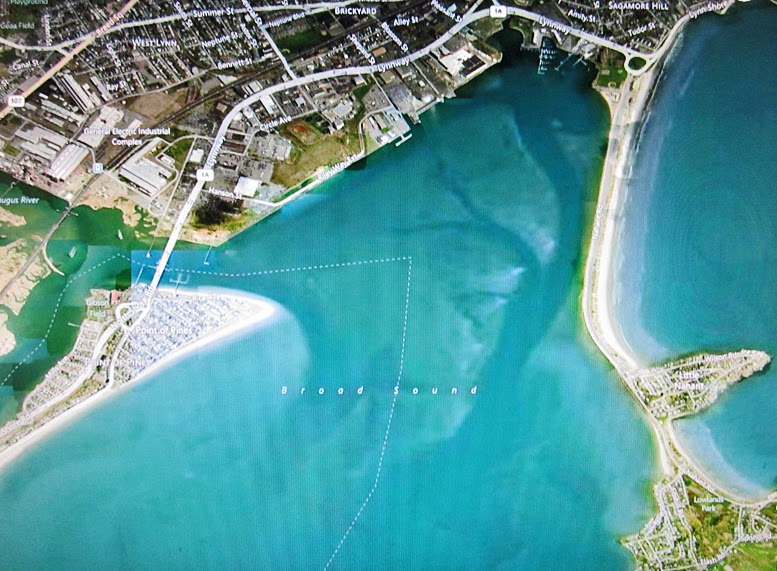
     This is an aerial view of the area located on the Broad Sound just inside Boston's harbor area. There's a lot of shallow areas in the cove. Perfect place for a little night fishing adventure. At the top center of the pic (near the 1A route number), that building with the white roof is where the launch ramp is located. The darker areas are the deep spots, the shallow areas are highlighted in beige.


     For a better weather forecast for that area of Boston, go here: http://www.boatma.com/bostoner.html

Monday, February 17, 2014

Third Beach - Middletown,RI

     On an outing last year with our kayak fishing group, the "Kayak Committee", a sub-club within the Rhode Island Saltwater Anglers Association, I had the chance to visit a new launch site that I've never been to.

     Located in Newport County, RI on the Sakonnet River inside the southern portion of the Narragansett Bay lies a hidden gem for kayak anglers, and it's called Third Beach.

     Third Beach is located on the island of Newport,RI which is accessible via a pay toll - both to & from the island. Cost is based on $2.00 per axle. Example: a 4x4 truck is $4.00 one way, and $8.00 round trip, as of 2013.

    Third Beach is also hot spot for beach goers and paddle enthusiasts. Kayaks and stand up paddle boards are available for an additional fee. Those wishing to fish out of their kayaks, must get there before 8 am, otherwise they will face an additional fee just to park there.

     In the photo below that was taken in the fall, it does not show the guard shack at the entrance to the parking area, but it also shows that though there is a lot of land, only half is paved while the other is grassy.
     Do your best to get here early, as the parking lot tends to get overcrowded by 11 am in a hurry.
    

     Here's another aerial view (below) of the launch site on the center/left, along with the area we fished at on the tip of the cove area (center). The white markings in the middle are actually rocky reefs, as is the rocky coastline heading south from the tip of the land mass, a favorite spot for all kinds of fish - Striped Bass, Bluefish, Flounder, Blackfish, and Tautog.

     * When the wind picks up, head in quickly, because the swells near the reefs can get dangerous!

     My Eagle fish finder was literally covered in black because of the massive amounts of fish in the area near the tip of the cove. I had several strikes on tube rigs and eel rigs. There aren't too many outings that I've been on that get me excited, but this was one of them! I will try to get out there before the season's end in the Fall 2014..

     The pathway on the land's mass is part of a nature preserve with walking trails for bird watchers, and an observation tower at the tip.


Pleasure Beach Boat Launch - Waterford,CT

     I've mentioned in the past about local boat ramps that I use to go fishing nearby, all within a tri-state area (Connecticut, Rhode Island, and Massachusetts), and this is my first post on that.

     I first heard about this launch site when I had hire a new guy to remove snow off my 600+ ft driveway. We got on the subject of fishing from a kayak and how the launch ramp I was using was not the greatest to access the Long Island Sound. The outgoing tide coming out of the Niantic Cove, Niantic,CT was dangerous, to say the least. So, he mentioned that he launches from a small boat launch area in nearby Waterford,CT off of Dock Rd. Because we fish at dusk, parking is free.

     Here's a brief description of the area:
     

Pleasure Beach

Pleasure Beach is one of the many beaches in Waterford, Connecticut. It is located at the end of Dock Road. Not only does Pleasure Beach have a beach, it is also the location of a public boat launch. Pleasure beach is part private and part public. The membership cost for a family of four is $825.00, which includes the new member fee of $500.00; this is for the first 3 installments – total cost is $1,500.00; the assessment fee of $250.00; this includes 2 free badges per household, the extra badges fee of $50.00, and a $25.00 cost for each additional badge; children of eight and over are required to wear a badge, and the voting member fee, which is $25.00 for one person to vote. To become a member you have to live in certain boundaries. The private side membership includes attendance to all beach activities. Some activities in the past are cocktail parties, beach cleanup at the start of the season, sand castle contests, and an annual beach picnic. The public side is marked and is open to the public with a path down to the beach and a parking lot a short walk down.


     Let's take a look at the area (West). This is the Pleasure Beach Boat Launch located off of Dock Road, which is a short paddle across Jordan Cove to the warm water run off behind Millstone Power Plant. Ample parking is located to the left when you pull in. Restrooms are across the parking area. A smaller parking area is reserved for the beach residents only. Located to the left of the boat ramp, this is a hot spot for surf fishermen that fish off the rocks. Pleasure Beach is situated to the far left of the photo below.


     Here's an aerial view (North) of the boat ramp and of Jordan Cove. The small bridge connects to the boat launch area is extremely narrow and has a weight limit.


     And, here's another aerial view (North) of the boat launch (far right), including Jordan Cove (mid top center/top right), and Millstone Power Plant (far left). The beige colorings show the shallow spots in the cove area, while the darker hues show the deep spots within Jordan Cove.

     A hot spot for fishing activities is at the mouth of the warm water run off behind Millstone Power Plant which is a known hangout for Striped Bass & Bluefish.